Airborne Electromagnetic Surveys
Ogallala Aquifer in GMD1
Low-Flying Helicopters to Help Uncover Aquifer Secrets
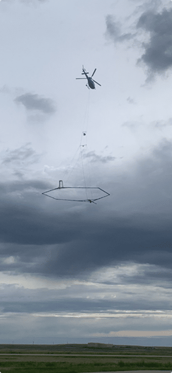
Conducted in mid-June and continuing until early July of 2025, residents of west-central Kansas witnessed a low-flying helicopter towing a large hexagonal frame. This unusual arrangement is part of a project to map groundwater conditions in the Ogallala aquifer in Western Kansas Groundwater Management District No. 1.
Thanks to funding from the Governor’s Office and the Kansas Water Office, GMD1 and the Kansas Geological Survey, working with Aqua Geo Frameworks, LLC of Fort Laramie, WY, planned the helicopter flights to develop a better understanding of the Ogallala aquifer. In 2024, AGF performed 2,500 miles of similar airborne electromagnetic surveys in Northwest Kansas Groundwater Management District No. 4.
https://kgs.ku.edu/airborne-electromagnetic-survey-aquifer-conditions-western-kansas
Flying Low to See Deep: Helicopters Equipped for Aquifer Mapping
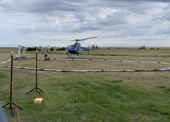
Scientific equipment will hang below the helicopter 100 to 200 feet above ground. The equipment is designed to map geologic structures and groundwater resources to depths of 1,000 feet below land surface. The helicopter will be flown at about 50 mph by pilots who are specially trained for low-level flying and have a great deal of experience with airborne electromagnetic surveys. Flights will not occur over residential areas and other buildings, livestock feeding operations, or wind turbines.
Airborne electromagnetic surveying will take place in west-central Kansas in mid-June into early July as part of a multiagency effort to assess conditions in the Ogallala aquifer. The Kansas Geological Survey, based at the University of Kansas, is part of the project.
Charting a Sustainable Future for a Critical Water Source
The Ogallala aquifer is the principal water resource for agricultural, industrial, and municipal use in GMD1. Intensive pumping of water from the aquifer over the last 60+ years has resulted in large groundwater level declines in Wallace, Greeley, Wichita, Scott and Lane counties. The information obtained in these flights will allow GMD1 and the Kansas Geological Survey to better assess the nature and continuity of water-yielding materials in the aquifer. The ultimate objective of the project is to obtain information that will assist GMD1 in developing strategies for charting more sustainable paths for the Ogallala aquifer in the district.
For further information about the planned survey, contact Katie Durham, GMD1 manager (kdurham@gmd1.org, 620-872-5563), Jim Butler of the Kansas Geological Survey (jbutler@ku.edu, 785-864-2116), or Jared Abraham of Aqua Geo Frameworks (jabraham@aquageoframeworks.com, 303-905-6240).
The Kansas Geological Survey is a non-regulatory research and service division of the University of Kansas. KGS scientists study and provide information about the state’s geologic resources and hazards, including groundwater, oil and natural gas, critical materials, and earthquakes.
Currently, GMD1 is awaiting the results of the mapping. Expected date of receiving the results is towards the end of 2026.
GMD1 Media Day PresentationAEM Mapping Exposure LevelsAEM GMD4 Presentation